Search

Our Family Adventures

Life and Adventures….

Category

Camping

Arkansas Ozarks Part 1

Jared and I recently took a short trip to Arkansas. For me the trip was two fold. My father passed a way 10yrs ago in the Fort Smith area and I have long since wanted to find and visit his grave. As with a lot of family stories, my parents divorced when I was young and my father slowly drifted out of my life. Reasons and back story don’t really matter any more, time moves on and so have I. But the need for some closure was heavy for me.

So we set out after work one afternoon and drove and drove until we finally decided to pull in about midnight to the first campground we came across. Which happened to be right outside of Mena, Arkansas called Iron Mountain. After paying our fee at the site sign, we drove around in the dark unsure of where we were supposed to be setting up but eventually settled on a spot that the deer had just been grazing in moments before. We interrupted their midnight snack. It was a quick..setup the tent, throw in the sleeping bags and crawl in night since our scouting for the shower house ended in a bust. Not the most comfortable of nights, but oh well. It was quite cold and our spot near the roadway was a bit noisy.

The next morning we packed up and again scouted and found the shower house. It was nice and big and had lovely hot running water! If you’re ever in that area I recommend staying there, very pretty place …just pick a site further back from the roadway. After cleaning up we headed out to grab breakfast, and headed towards Fort Smith. I was now seeing Arkansas in the daylight and could try and catch some photos…even if they were from the Jeep window going 60mph.

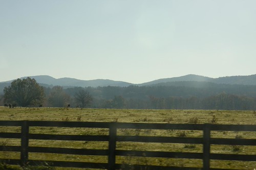
Lovely Quachita Mountains and forest
Ouachita Mountains

Quachita Mountains
Lots of logging trucks along the way, also lumber mills.
Logging trucks

Fort Smith was a really nice place, very pretty. Lots of factory work there. I even got a shot of Mr. Peanut!
Mr. Peanut factory

The rest of that morning did not work out the way I had hoped all these years, but that story is one I’ll keep for my own. After finishing up in Fort Smith, we headed out and headed east.

I loved seeing so many old barns and farms along the way. I think I could do a whole series on Arkansas barns.
Old Barn
Finally in the Ozarks!
Ozark Mountains

I have to say driving on all those curvy steep mountain roads made for a queasy afternoon. But it was fun. When we reached Jasper, we found the road to Kyles Landing and headed down the dirt road into the canyon and towards the campground.
Kyles Landing road

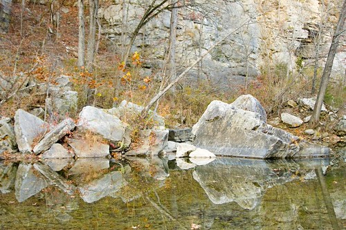
Once finally down there after a long and steep decline we picked out a camp site with the Buffalo River below us and beautiful cliffs behind us. Then explored a bit down by the river before it got dark.
Kyles Landing camp

Kyles Landing/Buffalo river

Kyles Landing

After dark crept in we sat around cooking our dinner, chatting, and dreaming of what lay ahead of us the next day. This is always my favorite part of camping.

Kisatchie Bayou Birthday

It seems we’ve added a new little companion to some of our adventures. Jared thought it would be fun to take Cheyenne on a camping trip for her 6th birthday. Being her first overnight outing we chose a location at Kisatchie Bayou because there was a creek and sand bars and rocks for her to play and keep occupied with. Other than her deciding that scouting firewood was too much work, and the 1 1/2 mile hike up hills was not fun about halfway through….she loved it. Seriously loved it. As in every weekend since she asks to go camping or hiking. LOL! Of course Daddy is happy and planning more trips 😉

Not exactly the low gear, quiet location type camping trips Jared and I do together. Till she gets older and more used to camping we’ll have a bit more gear and choose locations she might enjoy more.

Dad’s yummy camp breakfast!

Before we started the hike on the Longleaf Vista

Lots of breaks with a little one and little legs.

We set up the camera with self timer on a bench so we could get a family photo.

It was a really fun weekend and now that she’s caught the bug like us there will surely be more.

Back to Camp Livingston for more Caching and Exploring…

This time we brought my son and his fiance. They’ve never done a camping or caching trip with us so it was fun to bring them along! After driving around Livingston with the trailer in tow we ended up choosing to set up camp at Stuart Lake nearby instead of inside the grounds of Livingston.

The guys decided to have a friendly competition to see who could start the fire first with what they had on them…guess it depends on what you pack. LOL!

Jared got it going first, but I think he kinda cheated… ;D

Along the way during our exploring of Livingston we found a crabapple tree! I took a few fruit to see if I could seed them. ( 6 months later, a few sprouted but I lost them )

Sometimes you find cool little places along the way like this.

The main excitement was finding the old “Ice house” that we had been told about by one of my blog readers! (Thanks!) It was such a cool place to explore and take shots of.

Lots of cool graffiti out there…

Also took a peek into what I presume they call the tunnels. Went quite a ways back and was luckily dry that day so was easy to explore. (We’ve gone back since and not good when wet after so much rain)

We found a cool looking ‘fruit’ (not edible!) and found out it’s called and Osage Orange or Hedge Apple. The tree was prized in Native American days for use for bow making. The wood is extremely hard and strong.


Outside entrance

We also found the entrance to an underground area where bats live that is also the home of a cool geocache. Here is a little toy soldier hinting/pointing the way.

And we also found lots of other foundation work and left over history from this area.

We also made a stop at Camp Claiborne on the way home to see if we could find a geocache that had eluded us for a while near the Officers Club and rec pool.

Finally found that sucker!! Yay!

It had a cool travel bug in it so we took it and sent it to a new home later at Sam Houston park.

We also stopped to grab a geocache along the way home in McNarry, La and had to walk across this old pine tree to get there.

All in all a fantastic time. Definitely a place we will go back to time and again to explore.

All of the shots from that trip can be seen here :

Fullerton Saw Mill Town

Here are some pictures of the Fullerton Mill Town ruins that we found on one of our trips in December of 2009.

For more in depth information on the origins of Fullerton you have to take a look here: Venture Vernon

Fullerton Saw Mill Town by GypsySoul

Here is the marker at the recreation and camp site area giving some information about the history. There is also a board that has photos and more info.

There is a trail that will take you along side a few of the ruins. It’s about a 1 1/2 mile long. I can’t remember which of  the ruins are seen along the trail because we don’t stick to a trail. We’re just adventurous that way. LOL! Most of the ruins and especially the larger ones are found if you venture out into the thick woods. There really isn’t any good mapping system available to let you know what used to be where and how to find it out there. But they do have a team of researchers that have done some mapping. We pretty much just take off walking and keep our eyes out for structures, we enjoy the hunt…and the finds.

Doesn’t he look serious. He is serious about his exploring. LOL…

Part of the old mill.

Storage facilities I believe. There were many rows of these tall walls.

Can’t remember if this was the theater or bank maybe

Remnants of the old community swimming pool.

The Fullerton Saw Mill Town is one of our favorite places to go. Whether it’s exploring, camping, biking, hiking…we just really think the area is neat.

Check it out sometime, bring water, wear boots, have a gps if you tromp off into the woods. The best time to go is winter time because the over growth is deadened down a bit and it’s easier to spot and find stuff.

Day 3 Back at Camp Claiborne

Our last night was a doozy. After a night of steady rain, we woke to a wet mess. We had to take our bedding and tent and hang them to dry before we could attempt to pack them back up.

After hanging our stuff, we headed out on foot into the ATV trails because there were a couple of Geocaches hidden out there. Along the way we came across some of the old ruins.

I’m not sure what it is, but there are more just like it in another area of trails that we rode on last year. If someone is familiar with what this is/was, leave a comment and let me know.

Here’s the tiny cache we found nearby…magnetic and about 2-3 inches big (The black dot in the middle there). It was stuck to the underside of the rails. Not sure how this thing stays on there with all the rattling of ATV’s that pass over it all the time.

This next cache we walked a long way through the woods to find. It was actually the second part to a multi cache that is stationed at the entrance to Camp Claiborne. Love the old tree it was stuck in!

We also tried our luck again trying to find the cache that is over by the pool. That one is hard to locate. But I busted out my wide angle lens and took advantage of some more shots of the cool pool.

And of course the Officer’s Club too. I just love this place!

We traveled miles of old base roads looking for caches. Some in better condition than others. And some roads weren’t really roads, more like trails…which can be nerve wrecking for me at times. JRed says he’s gonna have to start giving me Xanax before we take these trips so I don’t trip out on his trail driving. LOL!

In this next shot I’m standing on what used to be an old bridge, but is now a big rubble of concrete…taking the shot of our path in. That was a special cache because it was our first FTF (first to find) since doing Geocache. It had eluded another big group that had been out there in October looking for it.

The next cache took forever to get to, and was a maze of old roads on the southwest side of the base by the old rail area. There used to be a rail bridge that went across from this spot to the other side (not shown). That big hole is a lot deeper than it seems here on the picture.

On our way out we accidentally came across on old building that was evidently used for sewage treatment back in the day. It was fenced off and had warning signs all around it, which no other buildings out there have. This building was really big, bigger than most we found out there. It goes way back.

The last cache at Claiborne we found that day was one that was just literally put out two days before, by the old Theatre ruins.

It was a small one, an old pill bottle hidden in one of the old pipes.

And finally we ended the day over by Indian Creek, near the Bass hatchery there is a cool area with a burned out old bridge that people fish off of. We found this cache hidden in this tree log.

We had a great time on our 3 days spent caching and camping around the old bases. We found some cool areas, met cool folks, and had some great quality time together. Of course it was nice to get home to a nice hot shower and clean clothes though ;D

And since then I’ve been looking into some more history of the old hospital in Pineville. I’m putting together a post with some of that info, so hopefully I’ll have that up soon.

Day 2 Camp Livingston and Pineville, La

The second day of the trip we headed towards Camp Livingston. On the way we stopped to catch a cache that is hidden as part of this historic pine tree. The hider did a good job because that one eluded us. While there, an older man from the Dry Prong area stopped by to see what we were doing. Turns out he has an antique shop in Dry Prong that carries really old cast iron pots. We had a great time talking to him and will have to go find his shop next time we are up there.

When we got to Livingston we found some of the old roads and drove around. It’s a really big site and had a large network of roads. I’m not sure what the site in this next picture is but it had a big foundation. **EDIT** My husband has informed me that this is the Gymnasium. We located a few caches along the way too.

We also found the swimming pool. This thing was *huge*, had to be way bigger than Olympic size. If you look on Google you can find it easily, there is a huge chunk of the woods taken out by this thing. It was hard to get any good shots of it, and even if I had you wouldn’t be impressed. Unfortunately vandals have nearly completely destroyed it. Shooting it up, dumping loads of trash in it. Here’s a shot of a piece of the side wall.

We later found an area where people park to get on the ATV trails, and had lunch there. I found this set of foundation that was kinda interesting. It was 3 really long concrete lanes. Not sure what it was for though.

On our way out of Livingston we tried to find the famed POW camp area. We really wanted to see the POW graffiti that is said to be there. But no luck…we couldn’t find it. All we found in that area was lots of animal bones.

On the way out we stopped in Pineville, La so I could get a few shots of the old Mental Hospital barn. Across the way was an airfield and this pilot looked as though he was practicing his approach because he would circle and go towards the runway then pull up and circle again.

I’d like to find some more information on this old barn and the hospital…which was shut down years ago. I was once told by a local that there was an underground tunnel that the cattle were herded from the barn, under the road and into a field to graze…which is now a lake. Hhmm…. strange.

Then it was across the old O. K. Allen Bridge and headed back to Camp Claiborne to make camp. We decided there was still much left there for us to explore.

We made camp at the MultiUse Trail area for ATV’s, and had dinner and fun by headlamp. LOL!

Day 1 Geocaching Camp Claiborne

On our way up to Stuart Lake and Camp Livingston we decided to stop off at one of our favorite spots, Camp Claiborne in Forest Hills, La. This also used to be an old military installation for World War II. There are lots of remnants there, and many we have yet to find. Claiborne was the first place we found a Geocache and it’s what got us hooked.

There are miles and miles of old roads still passable, but it can get kinda hairy at times if you don’t have some sort of off road type vehicle.

But it’s always worth the hunt when you find what you’re looking for…

One of the hunts took us to the old Officer’s Club. Lots of foundation work and even some tile left of the building.

Right past the Officer’s club is the Recreation Pool. There’s lots of beautiful graffiti now.

We then left Claiborne and set up camp at Stuart Lake, it got dark on us quick so we didn’t have time to explore the lake much. The campsite there is really nice, and little did we know there were showers with hot water available down a path nearby. We ended up setting up our own camp shower and boiling water….LOL…turned out to work great, but sure would have been easier to use the provided showers.

The rest of the shots from the day are here….http://www.flickr.com/photos/gypsysoul/sets/72157625651313817/

Blog at WordPress.com.

Up ↑